4 items found for your search. If no results were found please broaden your search.
(11/20/25 3:23am)
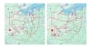
The current U.S. Congressional map (left) compared to the newly-approved U.S. Congressional map (right). The new maps target districts near Toledo, Akron and Cincinnati.
(11/20/25 3:18am)

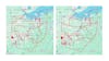
The current U.S. Congressional map (left) compared to the newly-approved U.S. Congressional map (right). The new maps target districts near Toledo, Akron and Cincinnati.
(11/20/25 3:05am)
The current U.S. Congressional map (left) compared to the newly-approved U.S. Congressional map (right). The new maps target districts near Toledo, Akron and Cincinnati.
(11/20/25 3:01am)
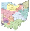
Ohio Secretary of State Frank LaRose published the updated map online following the Oct. 31 approval, which will be in affect until 2032.