By: Sydney Rushing
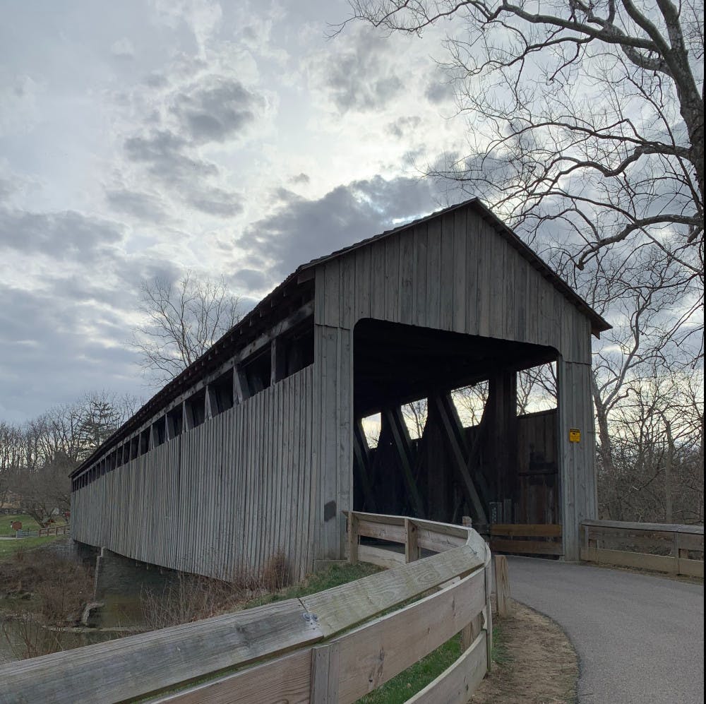
The Oxford Area Trail System, also known as OATS, is a successful city amenity that has made a positive and powerful impact on the Oxford community in recent years. For those who are not familiar with the trail, it is a paved path for bikes and pedestrians that spans from the Black Covered Bridge to Peffer Park with three additional entrance points along the route. This new system of multi-use paths should not to be confused with the Miami Natural Areas, which includes an additional 17 miles of smaller dirt trails that branch off of the paved OATS trail system. While the Oxford Area Trail System is managed, funded, and maintained by the City of Oxford, respectively, the Miami Natural Areas are owned and operated by Miami University. Although they are separate trail systems, the two entities work together to ensure a positive user experience.
On Friday morning, I logged onto Google Meets for a short interview with Jessica Greene, the Assistant City Manager for the City of Oxford. In addition to her many responsibilities in this role, she oversees the Oxford Area Trail System and its development. Since 2013, when she was the Enjoy Oxford Diretor, Greene has taken on the trail system as a passion project turned reality.
Greene is a longtime member of the Oxford community and is dedicated to unlocking all of its potential. She explained her initial vision of people coming together on this trail and said, “this would just be such a cool amenity for the community”. From a tourism perspective, the trail could drive the economy as people would travel to Oxford to enjoy the path, grab lunch in Uptown, and take time to discover all Oxford has to offer. Community members and city leaders were enthusiastic about the idea but questioned where the trail would go and how it might be funded.
In 2017, this vision came to life after discovering that a group years earlier had a similar aspiration and had actually planned and documented a path that stretched from the covered bridge to the horse stables. Much of the logistical work for the path had been written into the city’s Comprehensive Plan in 2008. The only thing left to do was to take action, fund the trail, and break ground which happened in 2017.
Today, the trail is made up of five segments each connected to one another, forming a 2.53 mile “C” shape that hugs the perimeter of Oxford. Each path is paved and meets ASTM standards, meaning the construction of the trails has been specifically engineered for its use and is recognized by the Ohio Department of Transportation. This also means that the trails take a significant amount of time to engineer and are expensive to construct.
Jessica Greene’s grant writing skills have played a vital role in the funding process of the trail that allowed the City of Oxford to proceed with its construction plans. “I had a grant writing background, so I just started running grants,” Greene explained. Still, this form of funding is not always a smooth or speedy process. Applying for a grant is a tedious, time consuming task and oftentimes is denied and must be edited and resubmitted before being accepted. If she has learned one thing through this endeavour, Greene explained, it is that “community change takes time.”
Oxford’s ambitious long term goal is to construct one connected 12 mile path by 2028 that goes around the perimeter of Oxford. The plan is to connect Peffer Park to Talawanda High School, the middle school, and the Oxford Community Park, and back to the black covered bridge.
“Seeing how many people are using the trail has shown that there was a need,” Greene explained. In Fall 2020 a trail count reported an average of 63 people used the trial in a day. Several months later the same count recorded 167 people per day. Another trail count is scheduled this Spring and is expected to rise significantly since the most recent addition of the trail was opened which connects the DeWitt Log House to Peffer park.
The completion of the most recent phase of the project could not have been more timely with the Covid-19 pandemic. The trail has offered residents a place to get outside and take a break from virtual school or working remotely this past year. Providing a safe space to meet a friend for a walk in an outdoor setting, the trail is conveniently located and easily accessible, all while offering immersion in nature.
Along with so many others, I too have taken advantage of the trials this year. Each time I go for a walk I am greeted by dogs, children on bikes, fellow walkers, and occasionally deer. Undoubtedly, the Oxford Area Trail System has transformed the landscape of the city and contributes a new layer to the richness of Oxford.
“We are building a community where people want to live and the trail is just one piece of the puzzle,” Green explained. So, whether you are an Oxford resident or Miami student, lace up your sneakers, get outside, and spend time enjoying all the beautiful Oxford Area Trail has to offer.
Enjoy what you're reading?
Signup for our newsletter
For more information head over to oxfordareatrails.org where you can find a map of the existing and proposed trails and up to date news.
Photo courtesy of Sydney Rushing.
Read More

Water soluble confetti: A small change with big impacts
By Tori Fee | May 7, 2026In previous years, sidewalks around the seal, the Tri-Delt Sundial and the area under Upham Arch could be seen covered in plastic confetti following graduation photoshoots. This year, water soluble confetti has offered an alternative to plastic through a university-wide initiative.
Oxford Community Arts Center fosters local art, history and friendship
By Ayla Peden | May 6, 2026Nestled on a plot along College Street, the Oxford Community Arts Center (OCAC) has been a place where locals and Miami University students alike can go to express their love of art and creativity. Over 25 years, the OCAC has grown into an integral part of the Oxford community.

North Chiller Geothermal project complete, next steps consider arena project
By Sarah Kennel | May 5, 2026Two years of construction on the North Geothermal Plant next to Millett Hall have come to a close. With big changes coming to North Campus in the form of a new arena and relocated intramural field, Miami's next steps in geothermal are taking this into account.